Sea Level Change
Sea Level Change Over Time
If you were at this point 7000 years ago you would actually be out at sea! The sea level was at its highest 7000 years ago and the level has gradually been getting lower as the land has been rising. Tentsmuir is constantly been added to and has grown 3.5km in the last 5000 years. This is due to a combination of the land rising, and the sea, waves and wind depositing new sand onto the beach.
What did it look like?
Panorama
Your browser does not have the necessary WebGL support to display this panorama.
This is a pill box built in the 1940’s as a World War 2 defense mechanism. It was originally located on the shoreline, but look how far inland it is now! This is because Tentsmuir is constantly being built up with more sediment.
How do we know?
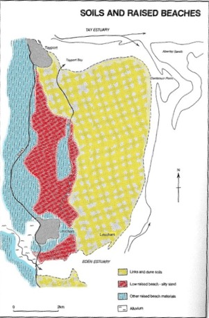
Raised beaches are geological features formed when sea level falls, leaving beaches “raised”, many metres above sea level, and therefore no longer susceptible to coastal processes.
This map shows the raised beaches which have been identified behind Tentsmuir, reflecting the fact that the beach used to be much further inland compared to its present point. These beaches were identified due to their long flat shape, and due to the sediments that were found on them. The map shows how coastal processes are continually changing the coast line of Tentsmuir. Tentsmuir’s location at the bottom of the Tay estuary means it receives huge quantities of sand each year. When the sediment is deposited, it slowly accumulates and causes the beach to grow. The map also highlights that not all of the beach has been growing - some parts have been eroded more rapidly. The combination of waves, wind and tides eroding and depositing sediment causes Tentsmuir’s coast to change rapidly and unevenly over time.
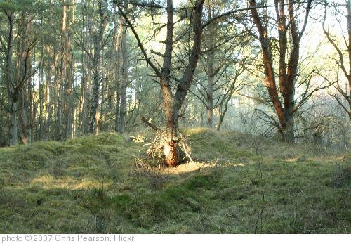
If you walk through the wood near to the coast in Tentsmuir, you will probably notice the ground is very hummocky. These hummocks are fossilised dunes. They were formed by the same process as normal sand dunes, and therefore show where the beach used to be, and what shape it was. You will notice that they are not all parallel to the current coast line - this shows that the beach has not grown outwards in a straight line, but the coast has curved and changed shape dramatically as it has grown.
Listen to Susie talking about how the sea level has changed over time.
Being a time travelling squirrel, I’ve been able to visit Tentsmiur at lots of different points in time – and goodness has it changed! One of the biggest things that has changed is where the sea is... At the moment you are probably standing by the beach, but if you were standing here 7 and half thousand years ago you would be a bit wet – as you would be in the middle of the sea! Back then, the beach used to be way back behind the Morton Lochs where you started the trail. Since then, the land has been rising upwards, so the sea has got further out. The land has risen because it used to be pushed down by lots of really heavy ice, but when the ice melted, the land bounced back upwards really slowly – this is called EUSTATIC UPLIFT. Strangely enough, Tentsmiur coast is still changing today, and is the fastest growing area in the whole of the UK, because the wind, the tide and the waves are constantly adding to Tentsmiur point up at the top of the park… but other parts are being eroded, and just one storm can change the coast line very quickly as it washes away lots of sand. It’s a little bit confusing, but you can always listen to this again!


